
 New York Time
 London Time
 Mumbai Time
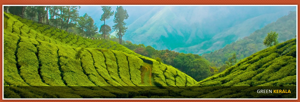


- Adventure Tour
- Goa
- Gujarat
- Golden Triangle
- Himachal Pradesh
- Kashmir
- Kerala
- Karnataka
- Luxury Trains
- Maharashtra
- Orissa
- Pilgrim tours
- Rajasthan
- Sikkim
- Tamil Nadu

| Backwaters Magic(Kerala) | |
| Best Of Back Waters | |
| Coconut Holiday | |
| Green Kerala Wayanad |

Green Kerala Wayanad

[9 Nights / 10 Days]
Day 1: Start from Calicut Rly.Stn. @ 10.00a.m.
Lakkidi :
On Kozhikode - Kalpetta Road, N.H. 212, at 58 kms. Pookode lake -3kms, Vythiri- 5kms. Lakkidi is known as the gateway of Wayanad, is situated atop of Thamarassery ghat pass. It gets the second highest degree of rainfall in the world. Lakkidi is one of the highest locations in Wayanad. It is situated 700 m above mean sea level. The lofty mountain peaks, the gurgling (sic sic) stream, luxuriant vegetation and the bird's eye view of the deep valley on the south, with its winding roads, is breath taking.
Chain tree:
This large Ficus tree, bound by a prominent chain is the source of the dramatic legend. As the tale goes, an Adivasi youth named Karinthandan was instrumental in guiding a British engineer through the difficult mountain terrain into Wayanad. Eager to take his credit, the engineer conveniently killed his guide, whose soul according to the legend constantly haunted subsequent travelers. It is further believed that a priest chained he troublesome spirit onto this tree.
Pookode Lake :
At Talsippuzha. 3Kms. From Lakkidi, Kalpetta – 15 kms. Pookode is a natural fresh water lake nestling amid evergreen forests and mountain slopes at an altitude of 2100 meters above sea level and having an area of 13 acre and 40 meter deep, very wide & deep. The lake has the shape of India's map. This perennial fresh water lake, nestled among wooded hills, is only one of its kinds in Kerala. The lake has abundance of blue lotus and fresh water fishes. The forests surrounding the lake hold many wild animals, birds and flies. The Panamaram rivulet - one of the main tributaries of the Kabani River - originates from it. Lying 3km south of Vythiri town, the lake is one of the most popular tourist spots in Wayanad. Spices and handicraft items are available for sale at Pookode. The lake is under the South Wayanad forest division and run by District Tourism promotion council. Boating facilities, children's park, handicrafts and spices emporium and fresh water aquarium are among the tourist attractions here.
Vythiri : Check-in Hotel.
Day 2: Chembra Peak
Near Meppady, Kalpetta -8 kms. Forest trekking of 1.5 hrs Chembra peak is the highest peak in Wayanad, at 2,100 meters (6,900 ft) above sea level. It is part of the Wayanad hill ranges in Western Ghats, adjoining the Nilgiri Hills in Tamilnadu and Vellarimala in Kozhikode. Chembra peak is accessible by foot from Meppady. District Tourism Promotion Council provides guides and trekking equipments on hire charges to the tourists. Permission from the forest office in Meppady is required for trekking up to Chembra Peak. The next point is watch tower from there on can reach the heart shaped lake within one and half hours trekking. A heart shaped lake which is called `Hridayathadakam' en route to the top of the peak is a major tourist attraction. The lake situates 4500 feet above sea level. During the rule of British, there was camp office. The lake is believed to have never dried up.
A 5 km journey from Meppady town through tea estates to Erumakkolli one can reach the forest office, from where a pass has to be acquired to trek the mountain. Also services of guide can be availed which might be very useful. The trek to the top takes 3 hours. Form the peak of the mountain one can have a glimpse of major tourist destinations like Vythiri, Karappuzha dam, Banasurasagra dam.
Day 3: Sunrise Wally must See.
Can see Meenmutty & Attamala falls. If one asks which is the must see place while passing through Wayanad, the answer is Sunrise valley. It is most striking viewpoints in Wayanad. From here one can see the Meenmutty waterfalls, then another waterfalls in Attamala. The Chaliyar in which both these falls unite can also be seen. It is situated in Kadassery in Muppainad Panchayath. In Meppadi-Vaduvanchal road go for 4 kms from Kadassery, there is the valley.
Soochipara Falls :
1km walk. At Vaithari Mala, Meppadi Kalpetta – 23 kms. Sentinel Rock Waterfalls, also known locally as Sentinel Rock Waterfalls, also known locally as Soochipara, is 23 km away from Kalpetta, located at Vellarimala village in Meppadi panchayat. This is a popular picnic spot and trekking area and the pool at the foot of the falls is ideal for a quick dip. The more restrained can have equally good fun just taking in the scenery.
The Sentinel Rock is also ideal for rock climbing. It is a spectacular waterfall where the water cascades down in three steps from a height of about 200 m in Vellarimala, Wayanad, surrounded by deciduous, wet evergreen and tropical Shola forests. Locally referred to as Soochipara 'Soochi' meaning 'Needle' and 'Para' meaning 'Rock', The 15-20 minute drive from Meppadi to Sentinel Rock Waterfalls offers scenic views of some of the best tea estates in Wayanad.
From Elevayal junction there is only 2 km distance to entrance of the falls. There is counter of Vanasamrakshana Samithi to give the passes. One has to make a walk for one km from the parking area as to reach the falls. There is a pond in its upper side called Cheenikund. The forest has many wilds animals.
Day 4: Kanthanpara Falls : Road touch
Meppadi – 8kms, Kalpetta – 22 kms, Sultan Batheri -23 kms. Surrounded by bamboo forests, the Kanthanparra Waterfall is more noted for the breathtaking beauty of the path leading to it than for the fall itself. At 30m, the fall is relatively smaller than Meenmutty or Sentinel Rock Falls, and perhaps on that account it is less frequented.But its proximity to the main road and the beauty of the surroundings make it a popular picnic spot. The vehicle would reach very near to the falls. The major advantage with Kanthanpara waterfalls is that it is an easy hike away from main road, and even children and trekking novices can reach the waterfalls with minimum effort. By road: Buses are available from Kalpetta . Get down at Rippon stop on Meppadi Vaduvamchal road
Meenmutti falls: 1km tough Walk
Stay at Meppady, Night Camp Meenmutty fall, the biggest and magnificent falls in Wayanad is at two-k.m. hike through the forest from the Ooty road, in which the vehicle would pass only up to one km distance. The rest of the path is to be covered by trekking and the path to reach the falls is perilous and tiring. But once you reach the falls you will have great deal of enjoyment in store.
In Vaduvanchal-Ooty road it is at 4 km distance. It is largest and most spectacular waterfalls in Wayanad, that cascades from a height of about 300m in three stages. It is the second largest waterfall in Kerala, located in the lush deciduous forest. The Meenmutty, Soochipara, and Kanthanpara waterfalls combined, feed the Chaliyar River. In Malayalam, the mother tongue of Keralites, Meenmutty means, 'Where fish are blocked'. Since there is upward falls where fishes can't swim further this name is given to the falls. The spot is easily accessible, as signboards would help you all the way. Vansamrakshansmaithi activists are managing the place.
Neelimala:
Near Vaduvanchal, Kalpetta – 27 kms.(1.5 hrs) Coffee Plantations,can see Meenmmutty falls , wally Neelimala viewpoint is one of the major tourist attractions in the scenic Wayanad. One and half hour journey from Kalpetta you would reach Neelimala passing the coffee plantations on both sides of the route Neelimala, adjacent to Vaduvanchal. It is an exceptional venue for trekking and camping and offers lots of exciting trails. From the Neelimala pinnacle you can enjoy an enthralling view of the cascading Meenmutty falls and the gorgeous valley in its forefront. Remember to move carefully since there are pits and slippery rocks.
By road: Board bus from Kalpetta and get down at Vaduvanchal. Pick another bus or a jeep to Cherambadi in Ooty route and gets down at Chithragiri. Trek one and half km to Neelimala, OR reach Chundal before Kalpetta and take the Ooty road to the right that goes via Meppadi and on reaching Vaduvanchal turns right. After three km the road turns right and climbs up a road up to tribal settlements, get down and trek.
Day 5: Pallikunnu church: Kalpetta – 19 kms.
Pallikkunnu Church is a famous pilgrim centre of Wayanad. This Latin Catholic church dedicated to Lourdes mother was built by a French priest Fr. Jefraine in 1905 at Meenangadi, about 19 km from Kalpetta. The major festival of the church falls in the month of February2 to 18. Another peculiarity of the church is that several rituals and practices of the church resemble that of Hindu temples. Catch a bus from Kalpetta to Vilmbumbukandam or Venniyode and get down at Pallikunnu stop.
Pazhassi tomb: (1805) Near Govt. Hospital. Monday OFF. Mananthavady – 1 kms, Kalpetta – 35 kms, S. Batheri -42 kms.
Pazhassi park: Mananthavady. Children’s park, Boating on Mananthavady River.
Korom mosque: Made by Nairs Mananthavady – 23 kms. Kalpetta – 47 kms. Korome Mosque is the one among the famous Muslim mosques in Wayanad. The mosque, which is 300 years old, is said to be constructed by people from Nair community and so often portrayed as a symbol of secularism. It is built in traditional Kerala style of architecture and the extensive woodcarvings are the noteworthy aspect. The annual Urs festival celebrated in this mosque attract thousands of people belong to different castes from far and near. By road: Get a bus to Niravalpuzha or Kuttiadi from Mananthavady via Nalam mile and get down at Korome town. From Kalpetta the route is through Padinjarethara, Taruvana and Vellamunda.
Banasura sagar: Kalpetta – 21 kms. Near Padinjarathara Banasura project, 25 km northwest of Kalpetta, is a mini hydel project. It is the largest earthen dam in India and the second largest in Asia and an ideal starting point for hikes into the surrounding scenic mountains. Banasura Sagar Dam, which impounds the Karamanathodu tributary of the Kabani River, is part of the Indian Banasurasagar Project consisting of a dam and a canal project started in 1979. The goal of the project is to support the Kakkayam Hydro electric power project and satisfy the demand for irrigation and drinking water in a region known to have water shortages in seasonal dry. In the dam's reservoir there is a set of islands that were formed when the reservoir submerged the surrounding areas. The islands with the Banasura hills in the background provide a spectacular view. The dam has now become a major tourist attraction of Wayanad. Boating facility at the dam will help you travel between small islands in speedboats. A small children's park is also present at the dam. 21 kms northeast of Kalpetta. 47 km from Bathery and 34 km from Mananthavdi. Buses are available from Kalpetta up to Padinjarathara. Proceed by jeep from there.
Kurumbalapatta mala: at Malakkara. The place was used as hiding place during the time of Pazhassiraja and Tippu Sulthan. From here on can see each part of Wayanad. In Kalpetta Malakara road, alight at Malakara and make a walk. By road: Get down at Malakara on Kalpetta-Malakara road.
Karlad lake: at Tariod Kalpetta – 16 kms, Vythiri – 8 kms. The lake spreads in an area of 7 acres and is a place where you can be with yourself, more so because it is not a huge tourist hotspot. The lake with all its beauty and facilities of boating and angling is still to gain its share of popularity. Boating is being halted for some time. The atmosphere is suited for trekking too. It is better to hire a vehicle as there is no direct bus service to the lake or board Kalpetta -Padinjarethara bus and get down at Kavummandam stop and pick an auto to the lake side.
Day 6: Thirunelli; vishnu temple 5.30 am to 1 pm and 5.30 pm to 8 pm.
Mananthavady -31 KMS (to Kattikulam – 10 kms, to Thettu – 8 kms, to Thirunelli – 13 kms.) Thirunelli is well known for the ancient temple located on the side of Brahmagiri hill in Wayanad and dedicated to Lord Vishnu. According to legend, Lord Brahma was attracted by the beauty of the area around the Brahmagiri Hill. Descending upon the spot, Brahma noticed an idol of Lord Vishnu on an Amla tree and installed the idol there. At Brahma's request Vishnu promised that the waters of the area would have the power to wash away all sins. The river near the temple is called Papanasini, which means the cleansing of sins. Thirunelli temple is the holy emotion of Wayanad. It is also known as Amalaka temple, Northern Kasi and Southern Gaya. Each day, many pilgrim's reach the spot seeking deliverance and for 'balitharpanam' here. Thirunelli temple situates 31 km distance from Mananthavady, in the lap of Brahmagiri hills in the Karnataka border, adjacent to Kodagu mountains. In Mysore road turn left of Kattikulam, Thettu road junction, the route to Thirunelli begins there. The temple is believed to be 1500 years old. Mainly importance is being given to four occasions like Karkadakavavu, Thulavavu, Kumbhavavu and Vaisakavavu in temple
Pakshi pathalam: Trekking. Mananthavady – 36 kms, Kalpetta – 71 kms, S. Batheri -78 km, Thirunelli- 7.5 kms. Permission from Forest Authorities necessary. Situated at an altitude of 1740m and accessible only by trekking, Pakshipathalam is home to several species of birds and is an ornithologist's paradise. It is located in the Brahmagiri Hills near Thirunelli. There is a cave here, which according to legend, was used by ‘Rishis’ (saints) for meditation in ancient times, has become a major attraction for tourists. It is a challenging tourist spot for any adventure-seeking tourist. The deep rock caves; formed among the thick blocks of rocks at the northern top end of the Brahmagiri are the abode of various birds and wild beasts. The place is bet knows for the presence of `Edible Nest Swift light' as its nest is made of solidified saliva and is used to make bird's nest soup. Here virgin forests, streams and steep hills together offer challenging avenues for trekking.
Day 7: Tholpetty wildlife santuary
Wayand wildlife sanctuary situates along the northern region of Wayanad, which is bordering Coorg district of Karnataka. Tholpetty Wildlife Sanctuary is connected to Muthanga and to the Nagarhole National Park in Karnataka, and is an integral part of the Nilgiri Biosphere Reserve. Flanked by towering mountain ranges on all four sides, Tholpetty covers an area of 345 SqKm. The sanctuary's deciduous forest cover, rich in bio-diversity, is home to 900-odd wild elephants, apart from numerous other species of animals. It is 24 km east of Mananthavady and 8 km west to Negerhole National park. It is 96 km form Kozhikode, 95 km form Mysore, 160 km from Ooty , 59 km from Kalpetta.
Best season - November to May Accommodation facilities are available at Mananthavady, which is the nearest town. The sramby, the wooden rest houses, and dormitories are available within the sanctuary .
Sights around Thirunelli temple, which is 32 kms from Mananthavady, Kuruva Island which is at 17 kms distance and Pakshipathalam which is 7.5 kms form Thirunelli. Safari in Tholpetti Timings 7 am to 9 am and 3 pm to 5 pm.
Day 8: Kuruva islands; Must see, Forest Range.
Mananthavady – 17 kms, Kalpetta – 40 kms, S. Batheri – 58 kms. The Kuruva islands are a group of three islands located in the middle of one of the tributaries of the east-flowing river Kabani. This 950-acre tract of uninhabited land is rich in flora and fauna. This island is isolated but an array of uncommon species of birds; herbs and orchids are the monarchs of Kuruva Island. It is a must see destination for nature lovers and a popular picnic spot. A perfect destination for those want to have a lazy walk through the shoreline of a river.
Its unique geographical characteristics make it a place where not only the leaves but also silence is evergreen being away from cities and thus it has become a place of attraction. Most recently, tourists drawn from all over the globe have identified it as the most visited place in the district. Kuruva comprises of more than 150 small islands and two fresh water ponds. Its group of many islands with a stretch of one hectare to 148 hectares. As many as three hour is needed to cover at least one island.
The island surrounded by streams and river can be accessed using rafts or fiber boats run by Kerala Tourism Department. Entrance to the island is restricted and monitored by Vana Samrakshana Samiti, a Dept of Forest of Kerala initiative to protect forest, and at times of heavy rain and frequency of elephants and other animals to the island a pass obtained prior to the visit of spot from Dept of Forest is mandatory. The service of guides is also available. The bridges made of bamboo and rare species of trees make the island unique.
Thrissileri shiva temple: 5.30 to 1 & 5 to 8 p.m Mananthavady – 7 kms, Kalpetta –32kms, S. Batheri -31 kms. Thrissilieri Shiva Temple is linked with the Vishnu temple at Thirunelli. It is believed that the performance of ancestral rites at Thirunelli remains unfinished unless followed by the offerings at this temple. At Thrissilieri, the ancient Jaladurga temple is also a must see and it is bound by water of Papanasini, on all sides that never dry up. By road: From Mananthavady via Ontayangatti to Kattatti junction (on Anappara road) thence to the temple road (1.5km)
valliyoorkavu durga temple:
6-2 & 5.30 to 8p.m. Kabani River, Meenoot Mananthavady – 3 kms, Kalpetta – 24 kms, S. Batheri -31 kms. Valliyoorkavvu Bhagavathi temple situates in Arattuthara, South east of Mananthavady in Pulpally road. This is one of the famous temples in northern Kerala. The Kabani River flows through the southern side of the temple. The 'Meenoot' is the main ritual at the temple. The principal deity of this temple is mother goddess Durga. Three principal forms of the principal deity are Bhadrakali, Vana Durga, and Jala Durga. Valliyoorkavu Bhagavathi Temple is an important worship place for the Wayanad tribal communities. Every year there is a fifteen-day festival celebration in the months of February, March and April.
Pulpally: seetha lava-kusha temple: S. Batheri -25 kms, Kalpetta – 34 kms. Pulpally Seetha Lava Kusa temple at Pulpally in Wayanad has a unique position among the temples of Kerala. This temple emerged as a place of worship amidst the verdant and lush greenery around. Seetha Lava Kusha Temple was constructed by Kerala Varma Pazhassi Raja and so was his favorite. This is the only temple that dedicated to Lava & Kusha.
Chithalayam falls: Forest Area, No Permission to visit. S. Bathery- 12kms. One has to trek around 4kms from Chethalayam for having a glimpse of this lovely small waterfall.
Day 9: Bathery jain temple: Kidanganad. 8-12 & 2 to 6 pm S. Batheri -1 kms. Kalpetta – 24 kms.
The temple is one of the most important amongst a series of Jain ruins spread across the state of Kerala, believed to have been built in the 13 the century. This Jain temple Wayanad is generally referred to as Tippu's fort. There is an interesting reason behind this name being given to Ananthanatha swami temple. King Tippusultan stored his ammunition in this fort during his reign. That is why this place is called Tippu's fort.
Muniyara: 3 kms away from Edakkal caves. 11 kms from Sulthan Bathery and 25 kms from Kalpetta The Muniyara situates in Andikavala near Ambukuthi hills in Sulthan Bathery proves that an advanced civilisation that existed in the mountains in stone ages too. These caves are made of huge rocky slabs. The view inside the cave is very exciting. The remnants of potteries and Stone Age accessories got from the Muniyaras are exhibited in the Wayanad Heritage Museum located in Ambalavayal By road: Buses are available from Bathery and Kalpetta, Get down at Kolagappra junction
Edakkal caves:
Trekking ; 9am-4.30pm. 5000 years old, 3 sets of distinct Petro Glyphs S. Bathery -12 kms, Ambalavayal – 6kms, Kalpetta -25 kms, A trek up the Ambukuthi hill near Ambalavayal takes you to the neolithic cave site of Edakkal. Etchings found on the walls of these caves have drawn the serious attention of archeologists and historians worldwide.The Edakkal Cave is located about 25km from Kalpetta is a 96ft long, 22ft wide and 30ft high cleft formed by the vertical split of a rocky mountain. The rock wall is etched with carvings depicting human and animal figures and objects of human use. These carvings speak of a highly civilized people of pre-historic age, and have drawn the serious attention of archaeologists and historians worldwide.
In 1894 then British Malabar Police superintendent F Foster found out rock tools used in neolithic era, when he was on his way for hunting. He also noticed Edakal caves after having an expedition there. He documented the pictures after having excavations. In 1984, State Archiology departement took over Edakkal caves and proclaimed it as a protected monument. Today it is a hub for many tourists,students and researchers . The hill is 4000 meters above sea level.
You can go to lower part of Ambukuthi hill via bus or car. From there one has to climb the rocks. Till mid way there are jeeps run by DTPC. The charge is Rs 40 for up and 30 for down. Upto 6 persons can travel in a jeep. Ticket counter is in the upper part. Fee for adults is Rs 10 and for kids Rs 5. Fee for camera is Rs 25 and viceo camera Rs 100. Taking pictures through mobile is not allowed.
Ambalavayal museum:
(Wayanad Heritage Museum.) Near Ambalavayal town. Rs 10 and Rs 5 for children, Video Rs 100, Still camera Rs 25 and theatre Rs 5 S. Batheri -10 kms, Kalpetta – 25 kms, Manathawadi – 42 kms. Located in the town of Ambalavayal, his museum is home to an interesting collection of artifacts that shed light on the history m, culture and heritage of Wayanad. Adjoining the museum is small theatre where one can watch a multimedia presentation on Wayanand. The archaeological museum has one of Kerala's largest collections of the remnants of an era dating back to the 2nd century A.D. The articles on display are a fascination for the historian, the archaeologist and the ordinary man alike. At the museum you can see articles as varied as clay sculptures, ancient hunting equipments like bows and arrows, stone weapons and other curios. Regional Agricultural Research Station is situated here.
PHANTOM ROCK: Near Kalpetta. Ambalavayal – 2.3 kms.
Phantom rock is a skull shaped rock, which has an eerie similarity to the face of Phantom. In the local area it is popularly known as Cheengeri Mala. Those who are adventurous enough can climb to its upper part. The surroundings of this rock have potential scenic locations. The scenic surroundings near the phantom rock make it a potential tourist trekking and camping location. The surroundings have lot of greeneries and rocks.
Karappuzhadam:
Ambalavayal – 4 kms, Kalpetta – 13 kms, This small dam was constructed for water needs of various parts of Wayanad. There are lots of fishes in this beautiful dam and in its surroundings one would spot butterflies and any birds. By road: Buses are available from Kalpetta. Get down at Ambalavayal and pick auto or jeep.
Day 10: Muthanga Wildlife Santuary
Muthanga wild life sanctuary is a part of the Nilgiri Biosphere region. It is a rain forest reserve connected to two major sanctuaries, Bandhipur National Park in Karnataka and Mudumalai sanctuary in Tamil Nadu. It has been declared as project elephant site and one can spot herd of elephants roaming in the area. Wayanad wildlife sanctuary was formed in the year 1973 and was brought under the Project Elephant in the year 1991-92 The Muthanga is on the way from Mysore to Sultan Battery. Wild animals such as Indian Bison, elephant, deer and tiger are spotted here. It is the second largest wildlife sanctuary in Kerala. It is bestowed with lush green forests and rich wildlife and houses some of the rare and endangered species of both flora and fauna.
Elephant rides are arranged by the Forest Department,Kerala. Discovering and observing the wildlife while being atop an elephant is an enthralling and unforgettable experience. It is spread over 344 km² and is about 16 km east of Sultan Battery, the nearest large town. This sanctuary occupies an area of 345 km2. The Western Ghats, Nilgiri Sub-Cluster including all of the sanctuary, is under consideration by the UNESCO World Heritage Committee for selection as a World Heritage Site. It is in Kerala-Karnatak border, about 16 km east of Sulthan Bathery.
By road: The sanctuary is connected by the road with 17 km from Sulthan Bathery, Kalpetta (42 kms), Mananthvady (59kms) and Kozhikode (96 kms).Mysore is at 95 kms distance form here and Ooty 160 kms. The nearest airport is Karippur and railhead is Kozhikode. Muthaumalai 123 kms. Timings - 7 am to 10 am and 3 pm to 5.30 pm.
